
The Brazilian government, in a strategic partnership with Google, has unveiled a comprehensive high-resolution satellite imagery map of the nation’s landscape, providing a critical historical baseline for environmental monitoring and the enforcement of the country’s Forest Code. This initiative utilizes advanced cloud-clearing algorithms and petabytes of historical data to reconstruct a detailed snapshot of Brazil as it appeared in 2008, a year that serves as a legal pivot point for land use regulations in the Amazon and surrounding biomes. By integrating this data into Google Earth and Google Earth Engine, the project offers a level of precision up to six times greater than previously available public datasets, empowering local authorities, researchers, and civil society to track land-use changes with unprecedented accuracy.
The Evolution of Brazil’s Environmental Monitoring
To understand the significance of this new mapping tool, one must look at the trajectory of Brazilian environmental policy over the last two decades. In the early 2000s, Brazil faced a catastrophic surge in deforestation. In 2004 alone, the Amazon lost more than 27,000 square kilometers of forest cover—an area roughly the size of Haiti. This period of rapid expansion in cattle ranching and soy production led to significant biodiversity loss and a measurable rise in local temperatures, prompting international concern and domestic legislative reform.
The Brazilian government responded with the Action Plan for the Prevention and Control of Deforestation in the Legal Amazon (PPCDAm), which combined satellite monitoring with field enforcement. However, the technology of the time often struggled with the persistent cloud cover of the tropical rainforest and the sheer scale of the territory. While the National Institute for Space Research (INPE) provided essential data through its PRODES and DETER systems, there remained a need for a highly granular, historical baseline that could stand up to legal scrutiny in land-tenure disputes.
The selection of 2008 as the baseline year for this project is not arbitrary. Under the revised Brazilian Forest Code of 2012, July 22, 2008, was established as the "cut-off" date. Landowners who cleared forest illegally before this date were granted certain amnesties provided they registered their land and committed to reforestation programs. Conversely, any clearing after this date is subject to full legal penalties and mandatory restoration. This "2008 Baseline" is therefore the foundation of the Rural Environmental Registry (CAR), the system used to regulate private landholdings across Brazil.
Technical Innovation: Processing the Archive
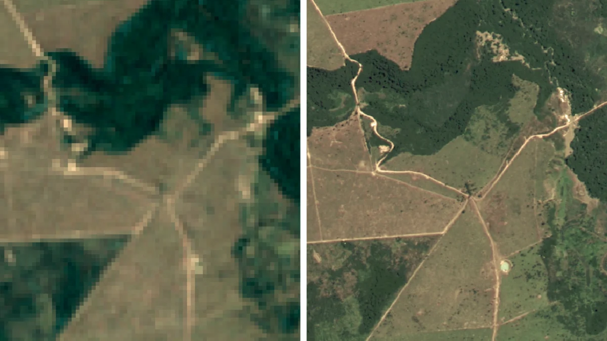
The creation of the new map required a massive computational undertaking, leveraging the infrastructure of Google Earth Engine. The primary challenge in tropical satellite photography is atmospheric interference; at any given moment, a significant portion of the Amazon is obscured by clouds. To overcome this, Google’s engineers and Brazilian scientists processed thousands of historical images from the Landsat satellite program, a joint venture between NASA and the U.S. Geological Survey.
Using a technique known as "temporal mosaicking," the team analyzed multiple images of the same location taken throughout the year. By identifying the clearest pixels from each pass and stitching them together, they were able to create a "cloud-free" composite of the entire country. Furthermore, the team applied sophisticated color correction and orthorectification—a process that removes geometric distortions caused by the Earth’s terrain and the angle of the satellite—to ensure that every meter of the map is spatially accurate.
The resulting imagery offers a resolution that allows for the identification of small-scale "selective logging," where individual high-value trees are removed without clearing the entire canopy. This level of detail was previously invisible in lower-resolution datasets, which often categorized such areas as intact forest. By revealing these subtle changes, the map provides a more honest accounting of forest degradation, which often precedes total deforestation.
Data Integration and Law Enforcement Capabilities
For the Brazilian Institute of Environment and Renewable Natural Resources (IBAMA) and the Ministry of Environment, this map serves as a forensic tool. With the 2008 baseline now publicly available and integrated into Google’s platform, law enforcement agencies can perform "change detection" analysis. By overlaying current satellite feeds onto the 2008 map, authorities can instantly identify where forest cover has vanished in violation of the Forest Code.
This digital transparency is expected to streamline the process of issuing fines and embargoing illegally cleared land. Historically, landholders could contest deforestation claims by arguing that their land was cleared decades ago. The high-resolution 2008 map effectively closes this loophole, providing indisputable visual evidence of the state of the land at the legal cut-off point.
Moreover, the availability of this data on Google Earth Engine allows for the democratization of environmental monitoring. Independent NGOs, academic researchers, and indigenous communities can now access the same high-quality data used by the government. This creates a system of "radical transparency," where local stakeholders can monitor their own territories and hold both private interests and government agencies accountable.
Broader Implications for Climate and Economy
The implications of this mapping project extend beyond the borders of Brazil. As the world’s largest tropical rainforest, the Amazon plays a critical role in the global carbon cycle. The ability to accurately measure forest loss is essential for Brazil’s participation in international climate agreements, such as the REDD+ (Reducing Emissions from Deforestation and Forest Degradation) framework. Accurate mapping ensures that carbon credits are based on verifiable data, increasing the confidence of international investors and donor nations, such as those contributing to the Amazon Fund.
From an economic perspective, the map also assists the Brazilian agricultural sector in meeting increasingly stringent international ESG (Environmental, Social, and Governance) standards. Major global importers of Brazilian beef and soy, particularly in the European Union, are moving toward "deforestation-free" supply chain requirements. By using the 2008 baseline to certify that their products do not originate from recently cleared land, Brazilian producers can maintain access to premium international markets.
Chronology of the Project and Future Milestones
The development of this mapping tool follows a decade-long evolution in the partnership between Google and various Brazilian stakeholders:
- 2004: Brazil records its highest-ever deforestation rate, triggering a national environmental emergency.
- 2008: The Brazilian government intensifies field operations; this year is later designated as the legal baseline for the Forest Code.
- 2012: The New Forest Code is enacted, mandating the use of the 2008 baseline for land regularisation.
- 2015-2020: Google Earth Engine begins scaling its capacity to process petabytes of geospatial data, partnering with various environmental agencies globally.
- 2022-2023: Intensive data processing occurs to refine the 2008 Brazil map, removing cloud artifacts and enhancing resolution.
- Current Phase: The map is released to the public and integrated into the official workflows of Brazilian environmental authorities.
Looking forward, the partnership aims to produce similar high-resolution annual updates. This would create a time-lapse history of the Brazilian landscape, allowing for the study of regrowth patterns and the effectiveness of reforestation efforts. As machine learning models become more integrated with satellite data, the system may eventually be able to predict high-risk areas for deforestation before the first tree is even cut.
Official Reactions and Expert Analysis
Environmental analysts have largely praised the initiative as a milestone in "digital conservation." By making the data public, Google and the Brazilian government have lowered the barrier to entry for environmental protection. Scientists note that while satellite imagery is not a substitute for "boots on the ground" enforcement, it acts as a massive force multiplier for underfunded agencies.
Statements from the technical teams involved emphasize that this is not merely a map, but a dynamic database. The integration into Google Earth Engine means that the data is "computation-ready." Researchers do not need to download massive files; they can run complex algorithms directly on Google’s servers to calculate biomass, analyze watershed health, or track urban expansion.
However, some experts caution that technology is only one part of the solution. The effectiveness of the 2008 baseline map depends on the political will to enforce the findings and the judicial system’s ability to process environmental crimes. Despite these challenges, the existence of a high-resolution, objective record of the forest’s state in 2008 provides a powerful deterrent against future illegal activity.
Conclusion
The release of the high-resolution 2008 satellite map of Brazil represents a significant advancement in the marriage of technology and environmental policy. By providing a clear, precise, and indisputable baseline, Google and the Brazilian government have established a new standard for national-scale environmental monitoring. As this data becomes woven into the fabric of law enforcement, international trade, and scientific research, it will serve as a vital tool in the ongoing effort to preserve the Amazon and ensure the sustainable development of one of the world’s most ecologically significant nations. The democratization of this information ensures that the task of protecting the forest is no longer the sole responsibility of the state, but a collective capability shared by the global community.
